Dr. Pavle Kalinić, Boris Guberina [1]
ABSTRACT: This paper presents the review of the issue of critical infrastructure in the City of Zagreb and the role of the Emergency Management Office in the above themes. There will be described operations and analysis at the level of the Office in the segment of civil protection reaffirmation, ie. the training of its members, which should be a significant support to operational forces in the event of an accident or disaster during an earthquake, being the biggest threat to the City of Zagreb.
KEYWORDS: critical infrastructure, civil protection, earthquake, flood, landslides
Introduction
Critical infrastructure is an important component in the field of the population Risk Assessment, material and cultural goods as well as the environment from disasters and major accidents in the City of Zagreb. This assessment determines the type, intensity and effects and possible consequences of natural and technological disasters and major accidents on the population, material and cultural goods and the environment, assess the needs and possibilities of prevention, reduction and removal of the resulting consequences, and builds a foundation for the development of protection and rescue plans of the population, with the work of all relevant operational and rescue forces and resources of available protection and rescue system. It is updating the Risk Assessment estimates made, due to the methodological and substantial changes in its content, based on a change of conditions in an urban area and increased vulnerability.Emergency Management Office performs tasks related to: organization and planning, financing and implementation of protection and rescue, defense, civil protection, fire protection, natural disasters and fire service in the execution of rights, obligations and responsibilities of the City Council and Mayor, making assessments, plans and other planning documents, preparation of general acts which prescribe the measures, activities and their implementation, and the development of individual acts in these areas, directing, coordinating and commanding operational forces and the implementation of operational measures and activities, confidentiality of data, information security and its control, as well as on other activities within its competence.Critical infrastructure includes power plants as well as gas, oil, and electricnetworks, stores, refineries, plants, communications and informationtechnologies, finances, healthcare, food, water, and transport, etc.. Endangering only one of these spheres can cause damages in millions, and in the long term may ruin a country economically, socially and politically(Raboteg, 2008). Furthermore, the Croatian capital Zagreb is a state and regional administrative center as well as the industrial and cultural center. Its area is 641 km2 and according to the last population census has just over 790,000 inhabitants.Since the utmost importance is citizens education on dangers threatening to people and material goods, Emergency Management Office through the distribution of educational leaflets to all mailboxes in Zagreb (so far: "4 Steps to Safety", "Hazardous chemicals", "Radiation protection", and "Earthquake") continuously inform citizens. Leaflets are also printed in Braille alphabet.Also, the Emergency Management Office annualy organizes thematic conferences focused on the protection and rescue in coordination with members of operational forces (fire brigades, police, ambulance, etc.).
The effect of natural and technological disasters in relation to critical infrastructure
Earthquake
Zagreb is located on high seismic area and this fact should be taken into consideration because of significant earthquake consequences for the population and critical infrastructure. According to the map of seismic Croatian territory for a return period of 475 years (Figure 2), the City of Zagreb is located in the zone of high seismic activity.The seismic activity in the City of Zagreb, under the old classifications earthquake scale,varies from VII to IX degrees Mercalli-Cancani-Sieberg (MCS) scales(shown in Figure 1). According to today's current the European/ harmonized standard, EN 1998-1/NA, which has been in force since 2011, the seismicity is defined by comparative peak acceleration of soil type A with a probability overshoot of 10% in 50 years for a return period of 475 years in the unit gravitational acceleration ie. in m/s2.
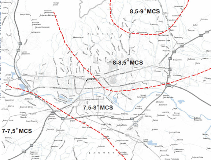

Figure 1. The seismic activity in the City of Zagreb, under the old classifications earthquake scale, varies from VII to IX degrees of MCS scales (source: Expert Service of the City of Zagreb)
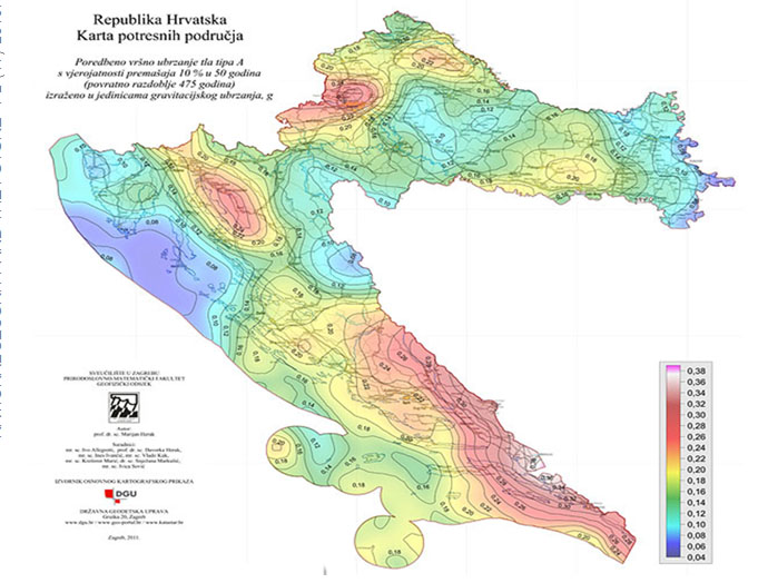

Figure 2.Croatian Territorial Earthquake Map for the return period of 475 years
The City of Zagreb is situated in the zone of high seismic activity. Seismotectonic active zones are characterized by different hypocenter depths, and are related to major faults: the Sava Fault, which extends through the slopes of Vukomeričke Gorice (hypocenter depth of most of the earthquake is between 10 and 30 km) and Medvednica Fault zone passing through Žumberačka Gora - Medvednica (hypocenter depth is generally between 5 and 17 km).Zagreb is situated in the zone bounded by few epicentral seismically active areas. The major epicentral area of the City of Zagreb is Medvednica mountain area.According to the aforementioned standards and existing calculations the most vulnerable city district is Podsljeme (ag,BC = 0,336g), and the least vulnerable city district is Brezovica (ag,BC = 0,256g). An enlarged segment of these areas is shown on Figure 3.A strong earthquake could cause major damage to transmission of gas and electricity facilities as well as telecommunication facilities which could cause a disruption in supply. In addition to the damage listed there is a possibility of some damage to the facilities of transport infrastructure (roads, bridges, viaducts, overpasses), which can make it difficult to implement activities of the removal of consequences and the establishment of regular life in the affected areas. Similarly, the earthquake could cause greater damage to the system of water distribution due to rupture of the main pipelines with the possibility of demolition of wells that supply water to a great number of households in the City of Zagreb.
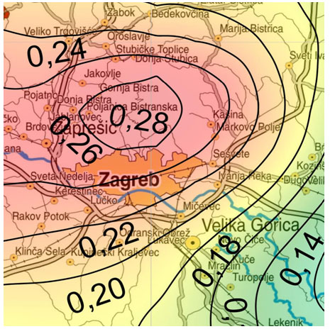

Figure 3. Enlarged segment of the map in the region around the capital. The administrative area of the City of Zagreb is located in the areas of ground acceleration which varies from 0.20g type A to 0,28g
City of Zagreb is divided into 17 city districts and in the event of an earthquake is provided for the reception area of citizens and situating tent settlements for each district, with the selection performed in previous GIS analysis of critical infrastructure for each area (Figure 4. shows the analysis of the gas infrastructure in selection of surface referred). Any form of human activity carries some risk. In order to reduce the consequences of possible disaster, whether natural or technological character, it is necessary to take measures for prevention and protection, as objects and people, and in this segment has great significance geographic information system which is today an indispensable tool in geospatial analysis of critical infrastructure (Guberina/Vuković, 2011).
The City of Zagreb is situated in the zone of high seismic activity. Seismotectonic active zones are characterized by different hypocenter depths, and are related to major faults: the Sava Fault, which extends through the slopes of Vukomeričke Gorice (hypocenter depth of most of the earthquake is between 10 and 30 km) and Medvednica Fault zone passing through Žumberačka Gora - Medvednica (hypocenter depth is generally between 5 and 17 km).Zagreb is situated in the zone bounded by few epicentral seismically active areas. The major epicentral area of the City of Zagreb is Medvednica mountain area.According to the aforementioned standards and existing calculations the most vulnerable city district is Podsljeme (ag,BC = 0,336g), and the least vulnerable city district is Brezovica (ag,BC = 0,256g). An enlarged segment of these areas is shown on Figure 3.A strong earthquake could cause major damage to transmission of gas and electricity facilities as well astelecommunication facilities which could cause a disruption in supply. In addition to the damage listed there is a possibilty of some damage to the facilities of transport infrastructure (roads, bridges, viaducts, overpasses), which can make it difficult to implement activities of the removal of consequences and the establishment of regular life in the affected areas. Similarly, the earthquake could cause greater damage to the system of water distribution due to rupture of the main pipelines with the possibility of demolition of wells that supply water to a great number of households in the City of Zagreb. City of Zagreb is divided into 17 city districts and in the event of an earthquake are provided for the reception area of citizens and situating tent settlements for each district, with the selection performed in previous GIS analysis of critical infrastructure for each area (Figure 4. shows the analysis of the gas infrastructure in selection of surface referred). Any form of human activity carries some risk. In order to reduce the consequences of possible disaster, whether natural or technological character, it is necessary to take measures for prevention and protection, as objects and people, and in this segment has great significance geographic information system which is today an indispensable tool in geospatial analysis of critical infrastructure (Guberina/Vuković, 2011).
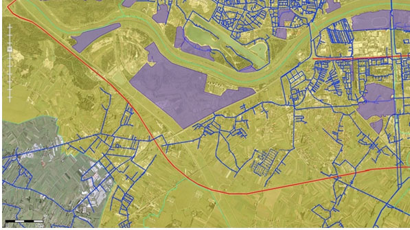

Figure 4. GIS analysis of infrastructure (gas network) in areas selected for tent settlements
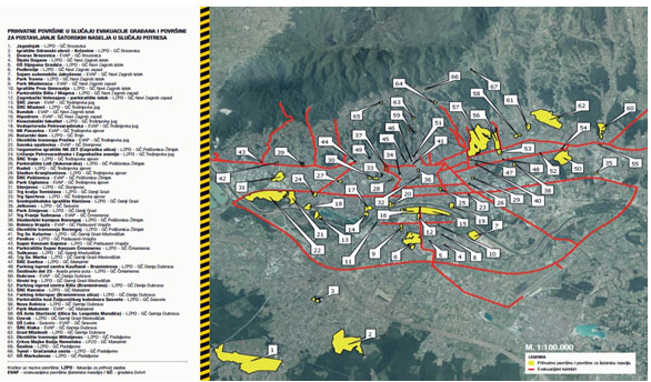

Figure 5. Leaflet „Earthquake“ showing all the areas for reception and tent settlements which is distributed to the citizens of the City of Zagreb in their mailboxes
Table 1.Possible problems in the city infrastructure in the event of a strong earthquake
|
Production and distribution of electricity
|
Possible interruptions of electricity distribution due to damage of substations and power lines. In case of earthquakes, buildings (substations, power lines) would have suffered certain minor damage because of such facilities which are legally required to be designed in accordance with an assessment of the earthquake. An earthquake would particularly act more intensively during the winter period and snow season, which would increase the time required to intervene.
Zagreb area is supplied with electricity from a number of sources: two production facilities TE-TO Zagreb and CHP Zagreb within the City of Zagreb, substation 400/220/110 kV Žerjavinec, TS 400/110/30 kV Tumbri Zagreb area and TS 200/110/10 kV Mraclin, outside the city of Zagreb.
|
|
Water supply and sewage
|
The risk of earthquakes is present because strong earthquakes are expected in the City. If there was a devastating earthquake it would lead to the cracking of pipelines and reservoirs that would cause interruption of water supplies to villages throughout the City. There is a possibility of creating a new pool with water. Sometimes, the dried-up wells filled with water or an existing one can dry up. In many cases, changing the capacity of the source and the water level in the wells. There is a possibility of damage or demolition to reservoirs.
Powerful earthquakes could also cause damage to the drainage system. The expected effects of the interruption of regular operation and disorders in the functioning of possible spills of waste water and sinking of basements. The ultimate consequences may endanger the health of the population. It is estimated that an earthquake can cause substantial damage to water mains and the sewage system in the old parts of town (Gornji grad - Centar, Centar, Podsused - Vrapče and Lower Town).
|
|
Food (production, storage, distribution)
|
In the event of an earthquake it can come to damages or the collapsing of buildings in which there are grocery stores, but given that households in the City have food supplies for a certain period, it will have no significant consequences for the population and functioning of the City.
|
|
Public health
|
Earthquake in the City would have major consequences and requirements of the public health system, both in terms of primary (care of injured, traumatized) and secondary needs (prevention of infections and epidemics).
If there was a collapse, the clinic would have relocated with its staff and resources to the new location. Due to good transport links and the proximity to major sites in the vicinity of the City, the functioning of public health or the provision of services to the population would not be denied or deprived.
|
|
Energy (natural gas, oil)
|
Harmful effects can occur only in case of strong earthquakes which would cause interruption of the gas supply. Gas pipelines are designed with an increased factor of safety, given that it is about, buried infrastructures which are not exposed to the direct influence of external factors, that are protected, and the pipeline does not pass through areas that are prone to landslides and gliding. Interruption of the gas supply has an impact on the normal way of life and work in the city, because gas is a significant energy source that is expected to use for heating homes as well as being necessary for industries.
|
|
Telecommunica-tions
|
Harmful effects may occur in case of an earthquake in which to prevent the demolition of exchanges, repeaters and mail facilities. Harmful effects manifested to such specific material damage and hampered communications in the City. At the base stations of mobile operators that were built on the roofs of buildings there no major damage can be expected, which will later depend on how the construction of facilities, in which they are located, and the quality of building materials.
|
|
Traffic
|
Road infrastructure in the City generally allows continuation of traffic in the event of an earthquake. The town is located in the lowland area so important road infrastructure consists of bridges, overpasses and underpasses, some of which can be damaged and destroyed. Temporary measures of training interrupted the traffic flow situation which will shortly be rehabilitated. A similar conclusion applies to the railway infrastructure.
|
|
Financial services
|
Part of the business premises of banks and the Croatian Post Office could be damaged for regular operations, and possible interruptions with ATM modem connections or damage to roads (disabled ATM supplements) reduction of financial services. It is expected that at least part of the capacity of financial services will be available.
|
|
Science, monuments and other national values
|
In accordance with the expected effects of an earthquake and the age of facilities (earthquake resistant constructions were represented with the knowledge from that time) with the identified objects, damage may occur to churches and demolition.
|
Floods
Given that the Risk Assessment found that the City of Zagreb is partly threatened by floods, the state company „Hrvatske vode“ is responsible for the measures to be taken in the flood case. In the case of flooding in the City of Zagreb, forces from the City are sufficient for the protections of endangered areas.To prevent flooding the retention systems that accept and drain water from Podsljeme zone were built. Due to frequent natural disasters, especially summer storms that include a large amount of rainfall, some objects of critical infrastructure can be flooded because of insufficient bandwidth sewage that can not collect a sufficient amount of water (such events are difficult to predict). In the city areas along the northern and southern banks of the river Sava the problems are groundwaters that flood building's basements during high water, but such events can not seriously threaten critical infrastructure facilities, but can make the work harder. Since all the settlements in the City of Zagreb are not connected to the main water supply system, it is possible that in case of flooding the local water supply network blurs during and after the floods, and pollution of water sources can lead to epidemiological and sanitary hazard. In table 2 are listed possible flooding impacts at specific sectors of critical infrastructure.
Table 2. Possible impacts of flooding in certain sectors of critical infrastructure
|
SECTOR CRITICAL INFRASTRUCTURE
|
PERFORMANCE
|
CONSEQUENCES FOR THE PERFORMANCE OF ACTIVITIES
|
CONSEQUENCES FOR USERS
|
|
water supply and drainage
|
blurring of water source
|
disturbance in the functioning
|
insufficient water supply
|
|
damage to the sewage system
|
disturbance in the functioning, spills of waste water, sinking of basements, pollution of water sources
|
endangering the health of the population
|
|
road traffic
|
damage to roads, overpass flooding
|
interruptions and difficult to carry out activities to eliminate consequences
|
a lack of access roads, delays in road transport, hindering evacuation
|
|
production and distribution of electricity
|
damage to substations and voltage network
|
longer interruptions of electrical energy
|
lack of electrical energy, difficulties in normal functioning of companies and households
|
GIS systems are also a great help in analyzing area that are exposed to floods and landslides. Office of Emergency Management permanently collaborates with the academic community (Faculty of Mining, Geology and Petroleum Engineering and Faculty of Geodesy University of Zagreb) and in coordination with it performs expert analysis of this subject matter in the Zagreb area. One example of prediction of flooding as a result of a dam rupture on the embankment of the Sava River is shown in Figure 6 (Basta/Cetl/Godler/Guberina, 2011).
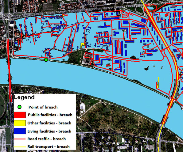

Figure 6.GIS analysis of floods in the case of breachingthe Sava River embankment
Landslides
The Landslides in the City of Zagreb are not an issue of a public danger because they have sporadic occurrence and the extent of the danger is not so large in relation to the world'slandslides. Most city landslides are the result of human intervention and there is a constant possibility of their activation. The most active landslides are in the area of Grmoščica and Fraterščica in the Črnomerec district. Landslides activation can cause heavy damage to the nearby facilities and other municipal infrastructure. Some of the most common causes of landsliding are extreme rainfalls, defective drainage systems, earthquakes, sudden lowering of the underground water etc.We should also mention the exploitation of mineral resources that have contributed to the occurrence of landslides (Müllerov brijeg, Grmoščica - brick clay, Kostanjek - marl and similar.). In order to protect the area from landslidesthe City of Zagreb carries out a series of measures which correspondto the measures and activities carried out by technically more advanced countries in the world which are faced with these problems. The strategy of protection against landslides in the future should be focused on two main directions. The first is to continue working on basic protection measures. The second one is to work on additional measures:
- Researches and development of studies for the development of the necessary documents,
- Cadastral conducting,
- Monitoring implementation, and
- Project documentation control.
Figure 7 illustrates the landslide in the area of Medvednica (red: active landslides, purple: initial landfall, yellow: calmed landslide, green: sanitized landslide).
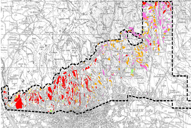

Figure 7. Map of landslides in the area of the City of Zagreb
The risk of a nuclear accident
The closest nuclear power plants (NPP) are located in Slovenia NPP Krško (10.6 km from the Croatian state border) and NPP Pakš in Hungary (74.1 km).Within 1.000 km from the Croatian national territory, that is, from its biggest population-centers (Zagreb, Osijek, Split, Rijeka) there are 40 operational nuclear power plants (NPPs) containing 89 power reactors (1 to 4 reactor units per plant). Reactors differ in power, age and technology.Locations of nuclear power plants over a distance of 1000 km from Croatiashown in Figure 8.NPP are potential threat to the City of Zagreb, depending on the degree of possible accident and meteorological conditions during its events.All technical installations, including NPP, generate certain risks. The biggest risks associated with nuclear power plants are in uncontrolled release of large quantities of radioactive substances into the environment. In order to prevent the occurrence of failures that lead to the uncontrolled release of radioactivity into the environment,the implementation of the principle of defense in depth ("defense in depth in nuclear power stations") which consists of introducing a number of active and passive barrier between the radioactive substance accommodated in the reactor core and the environment, is being done in NPP. Nevertheless, there is a little possibility of such a chain of events that would lead to the release of large quantities of radioactive substances into the environment.
The unexpected cases with ionizing radiation sources, i.e. dangerous sources, significantly are of lower intensity than those of the consequences arising from theunexpected cases with nuclear material. In the City of Zagreb there are 16 legal subjects performing activities involving ionizing radiation, most of which have sources of 3rd and 4th categorie.It is estimated that in all events that can be rationally predicted, the risk of the population radiation exposure is negligible.
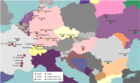

Figure 8. Locations of nuclear power plants over a distance of 1000 km from Croatia
The unexpected and uncontrollable cases when managing certain assets and conducting activities with hazardous substances
Technical and technological disasters occurre as a sudden and uncontrollable events when managing certain assets and conducting activities with hazardous substances. Nowadays, intensive technology development, use of new materials and substances in the production process, as well as neglecting already existing technologies and materials that are inadequately, are real and ever-present danger.The City of Zagreb has developed chemical and pharmaceutical industries, and in its manufacturing process uses hazardous substances, so the city of Zagreb is a large number of legal entities that have the different types of hazardous substances (ammonia, chlorine, hydrochloric acid, petroleum products, etc..).In addition to the above, in Zagreb there are more than 80 gas stations. In the event of the worst possible event "Worst Case" at the gas station, the radius of threat environment is 114 m, which means that there is a danger of the population and material resources violation.
Conclusion
Law on critical infrastructures from 2013, that has voted by the Croatian Parliament, in Article 3 defines "National critical infrastructure systems, networks and facilities of national importance whose termination action or termination of a supply of goods or services can have a serious impact on national security, health and people's lives, property and the environment, safety and economic stability and uninterrupted functioning of the government.". Critical infrastructure emerges as the most vulnerable segment of the everyday life that is subject to various external factors that may affect its vulnerability. Systems that need to protect critical infrastructure as far as possible should be built again, since during and after the Croatian War of Independence completely ignored (here this is especially relevant to the reaffirmation of civil protection, both in the City of Zagreb, as well as at the state level), and above all, the most important role should be played as correct and prompt implementation of the legislation adopted. It should be done through systematic and continuous implementation of training as well as operational and rescue forces update.
References
1. Basta, Ž., Cetl, V., Godler, I., Guberina, B., (2011) Role of the Office for Emergency Management – City of Zagreb regarding the problem of landslides and floods in Zagreb area, in: Ožanić, N., Arbanas, Ž., Mihalić, S., Marui, H., Dragičević., N. (ed.), 2nd Project Workshop on Risk Identification and Land-Use Planning for Disaster Mitigation of Landslides and Floods, Book of Proceedings, Faculty of Civil Engineering University of Rijeka
2. Croatian Geological Survey Institute (2011),Map of landslides in the area of the City of Zagreb,http://www.hgi-cgs.hr/pojava_klizista.html(retrieved 12.05.2016.)
3. Croatian State Office for Radiological and Nuclear Safety (2012), Locations of nuclear power plants over a distance of 1000 km from Croatia,http://cms.dzrns.hr/aktivnosti/pripravnost/nuklearne_nesrece/nuklearne_elektrane (retrieved 12.05.2016.)
4. Department of Geophysics, Faculty of Science, University of Zagreb (2011), Map of earthquake Croatian territory for a return period of 475 years,http://seizkarta.gfz.hr/karta.php (retrieved 05.05.2016.)
5. Emergency management Office – City of Zagreb (2016), Leaflet „Earthquake“http://web1.zagreb.hr/default.aspx?id=87101 (retrieved 11.05.2016.)
6. Guberina, B., Vuković, O., (2012.)GIS in Support of Protection and Rescue in Case of an Earthquake on the Model of the City of Zagreb, in: Toth, I. (ed.), 5th International Conference „Crisis Management Days“ – Book of Papers, University of Aplied Sciences Velika Gorica
7. Hrvatski Sabor (2013), Zakon o kritičnim infrastrukturama, Narodne novine, broj 56/13, http://www.zakon.hr/z/591/Zakon-o-kriti%C4%8Dnim-infrastrukturama (retrieved 01.05.2016.)
8. Raboteg, M. (2008.) Energetska sigurnost i zaštita kritične infrastrukture, in: Tatalović, S. (ed.), Energy Security and the Protection of Critical Infrastructure - Proceedings, Zagreb: Political Culture, p. 13